Version 6.00.09 - Pre-release
Support for GeoTIFF Raster DEM Files using GDAL
The GDAL library is now used for accessing raster DEM data files. In this initial implementation, GDAL is used to open and read GeoTIFF format files. This system can be easily expanded to include more common file formats as they are encountered and required.
GeoTIFF Raster DEM and Clutter File Support
Pathloss 6 can now index and use GeoTIFF format files in the Primary and Secondary DEM indexes. This will allow Pathloss 6 to use data from many sources that use GeoTIFF such as ASTER, CDEM, etc. To use GeoTIFF files, select the BIL Projected DEM or BIL Geographic DEM option as the Digital Elevation Model. Then click File Index to open the Index window. Select the Menu Item Import - GeoTIFF File. You can select one or multiple GeoTIFF files for import.
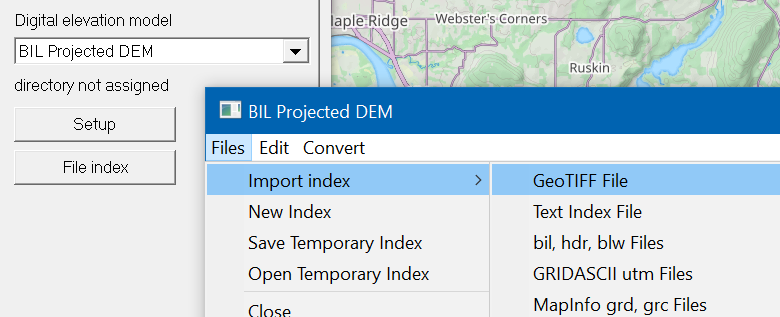
Pathloss will attempt to automatically set the projection from information encoded the first GeoTIFF file. If Pathloss is not able to determine the projection, the parameter string will be displayed to the user so the projection might be set manually.
GeoTIFF Files can also be used in the Clutter index by selecting BIL Projected Clutter or BIL Geographic Clutter and using the same menu item. GeoTIFF Files can be used for either height or category style clutter. In the case of category clutter, the definition table must be filled out manually for now.
With this update, the GDAL library is now integrated in to the Pathloss Vector and DEM systems. These systems will continue to expand with new features and capabilities. The final step for GDAL will be integration in to the Backdrop system of Pathloss. Once that is complete, GeoTIFF images can be shown directly on the network display.
Support for Terrain Data Download Through a Proxy Server
A proxy address and port can now be specified in the Program options. Click Configure-Options-Program Option-Startup and Defaults.
New Maps Tiles
Pathloss 6 now uses a topographic map as the default map style. These map tiles show contour intervals, hill shading as well as building footprints.
Versioning System Changes
Pathloss 6 now uses a semantic versioning system and no longer uses the build date for version control.
Improved Error and Warning Messages
Worksheet errors and warnings now directly link to an error and warning description page in the online help system.
User Selectable GIS Directory
While the the recommended location for downloaded GIS data is the users AppData/Local directory. Pathloss now allows the user to specify the root folder for GIS data. Click Configure-Options-Program Option-Startup and Defaults.